

Culture and faith
The Marshallese stick charts
Navigators made charts of palm ribs and shells to remember the swells between the atolls. They were used to find their way across open ocean.
- Where
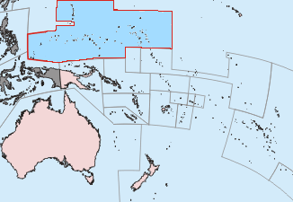
- Marshall Islands

Micronesian navigators and their stick charts, German and Japanese rule, the Bikini and Enewetak nuclear tests, and free association with the United States.
Independent in free association with the United States since 21 October 1986
The Marshallese stick charts, c. 1000. Image: Cullen328 · CC BY-SA 3.0, via Wikimedia Commons

Story 1 of 14 · Navigators
Culture and faith
Navigators made charts of palm ribs and shells to remember the swells between the atolls. They were used to find their way across open ocean.
About 890 years later
c. 1000 to 1885
Chapter II

Story 2 of 14 · German and Japanese rule
States and rulers
Germany annexed the Marshall Islands and used them for the copra trade.

Story 3 of 14 · German and Japanese rule
States and rulers
After the First World War Japan was given the former German islands in the Pacific. It settled tens of thousands of colonists and built ports and airfields.
Chapter III

Story 4 of 14 · US Trust Territory
War and conflict
US forces took the world's largest atoll from Japan in four days.

Story 5 of 14 · US Trust Territory
War and conflict
US forces took Enewetak Atoll, which became a base for the Pacific War and later the site of 43 nuclear tests.

Story 6 of 14 · US Trust Territory
War and conflict
The US tested atomic bombs at Bikini Atoll after moving its people away.

Story 7 of 14 · US Trust Territory
States and rulers
The UN made the islands a US-administered trust territory.

Story 8 of 14 · US Trust Territory
War and conflict
The largest US nuclear test was more powerful than expected and irradiated islanders and Japanese fishermen.

Story 9 of 14 · US Trust Territory
Science, trade and industry
The US army uses Kwajalein as a target for missile tests, and the islanders were moved to a crowded island.

Story 10 of 14 · US Trust Territory
Science, trade and industry
The US sealed nuclear waste in a concrete dome on Runit Island, which is now at risk from rising seas.
Chapter IV

Story 11 of 14 · Independent Marshall Islands
States and rulers
The Marshall Islands became self-governing with a compact with the US.
Story 12 of 14 · Independent Marshall Islands
States and rulers
The Security Council ended the trusteeship for the Marshall Islands and Micronesia.

Story 13 of 14 · Independent Marshall Islands
Culture and faith
Bikini was listed as a witness to the start of the nuclear age.

Story 14 of 14 · Independent Marshall Islands
States and rulers
Hilda Heine, a former education minister with a doctorate, was elected president by the parliament.
Journey complete
14 stories, c. 1000 to 2016. More events are being researched and added.
Culture and faith
Navigators made charts of palm ribs and shells to remember the swells between the atolls. They were used to find their way across open ocean.

States and rulers
Germany annexed the Marshall Islands and used them for the copra trade.

States and rulers
After the First World War Japan was given the former German islands in the Pacific. It settled tens of thousands of colonists and built ports and airfields.

War and conflict
US forces took the world's largest atoll from Japan in four days.

War and conflict
US forces took Enewetak Atoll, which became a base for the Pacific War and later the site of 43 nuclear tests.

War and conflict
The US tested atomic bombs at Bikini Atoll after moving its people away.

States and rulers
The UN made the islands a US-administered trust territory.

War and conflict
The largest US nuclear test was more powerful than expected and irradiated islanders and Japanese fishermen.

Science, trade and industry
The US army uses Kwajalein as a target for missile tests, and the islanders were moved to a crowded island.

Science, trade and industry
The US sealed nuclear waste in a concrete dome on Runit Island, which is now at risk from rising seas.

States and rulers
The Marshall Islands became self-governing with a compact with the US.
States and rulers
The Security Council ended the trusteeship for the Marshall Islands and Micronesia.

Culture and faith
Bikini was listed as a witness to the start of the nuclear age.

States and rulers
Hilda Heine, a former education minister with a doctorate, was elected president by the parliament.